Showing posts with label air. Show all posts

Thursday, January 30, 2014

Forecast: America to be hit by temperatures as low as minus 40 degrees

The image on the right shows that large parts of North America, the Arctic Ocean and Siberia are experiencing low temperatures.

What many people may not realize is that temperatures in the Arctic are actually a lot higher than they used to be around this time of year.

Temperatures in the Arctic have risen due to feedbacks as described in the post The Biggest Story of 2013.

As a result, temperature anomalies above 20 degrees Celsius now feature in the Arctic. As the image on the right illustrates, the once-common temperature difference between the Arctic and lower latitudes has been shattered, and this is weakening the Jet Stream and the Polar Vortex, in turn making it easier for cold air to flow down to lower latitudes and for warmer air to enter the Arctic, as described in posts at this blog for years, e.g. this post.

This is illustrated by the image below, showing that the Arctic is hit by an overall temperature anomaly of 6.55 degrees Celsius, while some areas in the Arctic feature anomalies above 20 degrees Celsius.


Forecasts show that on February 2nd, 2014, 1200 UTC, the Arctic will be hit by a temperature anomaly of 7.85 degrees Celsius, while on February 6th, 2014, 1200 UTC, the U.S. will be hit by temperatures as low as -40 degrees, as illustrated by the image below.


The video below shows temperature forecasts from February 1to February 8, 2014.


The video below shows temperatire anomalies from February 2 to February 9, 2014.


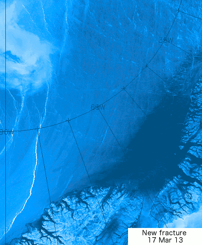
Meanwhile, the Gulf Stream keeps pushing warm water into the Arctic Ocean, as illustrated by the image below.

Click on image to enlarge - view updated animation at earth.nullschool.net 
The image below shows how high sea surface temperature anomalies stretch out from the point where the Gulf Stream travels at high speeds, off the coast of North America, all the way into the Arctic Ocean.


This has already resulted in methane eruptions from the seafloor of the Arctic Ocean that started several months ago and are continuing to date - ominous signs of more to come. The image below, which compares peak methane levels at two altitudes between January 2013 and January 2014, suggests that January 2014 peak levels have increased strongly, compared to January 2013 peak levels. Furthermore, that the rise in average peak readings has been most dramatic at the higher altitude.


This suggests that huge quantities of methane have indeed been released from hydrates under the Arctic ocean, and that much of the methane is rising and building up at higher altitudes. The increasing appearance of noctilucent clouds further confirms indications that methane concentrations are rising at higher altitudes.

Of course, the above analysis uses a limited dataset, but if verified by further analysis, it would confirm a dramatic rise in the presence of methane in the atmosphere due to releases from hydrates. Moreover, it would confirm the immensity of threat that releases from the Arctic Ocean will escalate and trigger runaway warming, as high methane concentrations over the Arctic are contributing to the anomalously high temperatures there. The risk that this will eventuate is unacceptable, which calls for comprehensive and effective action such as discussed at the ClimatePlan blog.


Monday, March 18, 2013

Huge patches of warm air over the Arctic

Over the past month or so, huge patches with temperature anomalies of over 20 degrees Celsius have been forming over the Arctic.

The three images below show such patches stretch out from Svalbard to Novaya Zemlya (top), north of Eastern Siberia (middle) and over West Greenland and Baffin Bay (bottom).


How these patches with warm air developed is further illustrated by the animation below, which goes from February 12, 2013, to March 18, 2013.


This is a 2.3 MB file that may take some time to fully load. 

Paul Beckwith, regular contributor to the Arctic-news blog, comments:
Paul Beckwith,
B.Eng, M.Sc. (Physics),
Ph.D. student (Climatology)
and Part-time Professor,
University of Ottawa
 

"The problem with this type of pattern is that there is a tendency for what is termed the AD (Arctic Dipole) consisting of exceptionally high pressures over Northern Canada to Greenland. When the air leaves this region heading for the low pressure regions (winds) it curves to the right (due to Coriolis force) and is thus driven from the Bering Strait region to the North Pole and then out Fram Strait, this conduit is like flushing the toilet on the ice. Warm water is pulled to the cold North Pole and the ice is driven out the Fram Strait into the warm Atlantic where it is melted."

"But the really big problem is that this high pressure area over Northern Canada is a ridge (blocking) that stays pretty stationary over the summers and is directly causing the heat waves and drought in the western US (2003, 2011, 2012). Another really big problem is that the part of the ridge over Greenland (or large GBI = Greenland Blocking Index); as discussed by Overland, Francis, et. al. in 2012 causes excessive melt in Greenland (as we saw in July, 2012 when 97% of Greenland was melting on the surface instead of the usual 40%). This is sending the Greenland albedo into a steep drop, causing even more heat absorption and melting."

To illustrate this further, Paul adds the animation below, from weather.unisys.com.

This animation is a 1 MB file that may take some time to fully load
Paul adds: "The Greenland high could reach 1070 mb in next few days; that will bring huge temperatures! By comparison, the world record highest was 1085 in Mongolia in December 19, 2001".

The 1070 mb high over Greenland is further illustrated by the image below, from weather.unisys.com.


Indeed, as the jet stream slows down and becomes more wavier, such patches of warm air can be expected to extend more regularly into the Arctic. The result can be a huge melt of Arctic sea ice, as well as a huge melt of snow cover in Greenland, which also dramatically lowers albedo, as occurred in 2012 and as discussed in the earlier post Greenland is melting at incredible rate.

This spells bad news for the Arctic sea ice, which may well disappear altogether this summer.

Paul further adds: "For the record; I do not think that any sea ice will survive this summer. An event unprecedented in human history is today, this very moment, transpiring in the Arctic Ocean. The cracks in the sea ice that I reported on my Sierra Club Canada blog and elsewhere over the last several days have spread and at this moment the entire sea ice sheet (or about 99% of it) covering the Arctic Ocean is on the move. Clockwise. The ice is thin, and slushy, and breaking apart."

"This is abrupt climate change in real-time. Humans have benefitted greatly from a stable climate for the last 11,000 years or roughly 400 generations. Not any more. We now face an angry climate. One that we have poked in the eye with our fossil fuel stick and awakened. And now we must deal with the consequences. We must set aside our differences and prepare for what we can no longer avoid. And that is massive disruption to our civilizations."

The animation below, from genomewiki.ucsc.edu shows cracks in the sea ice with the Wikipedia image underneath showing the location.


Related posts

- Polar jet stream appears hugely deformed
- Hurricane Sandy moving inland

Friday, October 26, 2012

Amplification of climate change in the Arctic

In contrast to multi-year old ice, first-year old ice—ice that formed only since the last melt season—is thinner, saltier, and much more prone to melt.


Over the years, the loss of sea ice has become especially manifest in the older ice, as illustrated by the image below.


Salt content and hardness play a part in multi-year ice’s resistance to melt, explains a recent NOAA article, but the main characteristic that allows the ice to survive the melt season is thickness.

Screenshots from: PIOMAS Arctic Sea Ice Thickness Simulation 1978-2011
The decline in thickness over the years goes a long way to explain the self-reinforcing character of sea ice decline in the Arctic.

As another recent NOAA article describes, there is “something extra” behind the record ice retreats of the past 6 years: each June, the prevailing winds shifted from their normal west-to-east direction and instead blew strongly from the south across the Bering and Chuchki Seas (left on the image below), over the North Pole, and out toward Fram Strait. (The length of the lines is qualitative: longer lines mean stronger winds.)

Average June wind vectors in 2007-2012 (orange) compared to 1981-2010 average (white) based on NCEP reanalysis data provided by Physical Sciences Division at NOAA ESRL. Map by Dan Pisut, NOAA Environmental Visualization Lab.

The image below shows the unusual air pressure patterns that gave rise to the wind shift. Air pressure across the Arctic in Junes from 2007-2012 was completely lopsided, with two pockets of higher-than-average pressure sprawled across the North American Arctic and Greenland. These areas of high pressure act like boulders in a river. They slow and disrupt the normal westerly flow of the wind, forcing it to make, large, meandering detours to the north or south.

Average geopotential height anomaly at 700 millibar pressure level in Junes from 2007-2012 compared to the long-term average (1981-2010) based on NCEP reanalysis data provided by PSD at NOAA ESRL. Orange colors are higher-than-average pressure; blue is lower-than-average pressure.     Map by Dan Pisut, NOAA Environmental Visualization Lab.
Arctic oceanographer and his NOAA colleagues think these “blocking highs” on the North American side of the Arctic created the unusually strong southerly flow that brought warm air into the central Arctic and over Greenland. The persistent southerly winds would help explain both the record low sea ice extent in summer 2012, as well as the island-wide melting of the surface of the Greenland Ice Sheet, which satellites detected in July 2012.

“This story started with us trying to figure out why the sea ice extents of the past 6 years or so have been so much lower than we would expect based on the long-term warming trend alone,” says Overland, “and we think this unusual circulation of the Arctic atmosphere is major part of it.”

Why, asks Overland, have these high pressure patterns have been forming so consistently each June for the past six years? The repeated appearance of these atmospheric features each June is so unusual that it’s the equivalent of a 1-in-a-1000 event. Can this be attributed to natural variability?

Instead, Overland’s hunch is that the cause is a change in the atmosphere that is itself connected to climate change in some way, possibly linked to record and near-record low June snow cover in the Canadian Arctic in recent years. “We don’t know that part of the story yet,” he says, “but this would certainly be the type of amplification of climate change [warming triggers changes that lead to more warming] we have been expecting to see in the Arctic.”

References

- Arctic Sea Ice Getting Thinner, Younger
http://www.climatewatch.noaa.gov/article/2012/arctic-sea-ice-getting-thinner-younger

- June wind shift a little something extra behind recent Arctic ice losses
http://www.climatewatch.noaa.gov/article/2012/june-wind-shift-a-little-something-extra-behind-recent-arctic-ice-losses

- Poles apart: A record-breaking summer and winter
http://nsidc.org/arcticseaicenews/2012/10/poles-apart-a-record-breaking-summer-and-winter/

- PIOMAS Arctic Sea Ice Thickness Simulation 1978-2011, published Sep 14, 2012 by ArctischePinguin
https://www.youtube.com/watch?v=G1TLzgSlGtQ

Related

- Arctic summer wind shift
http://arctic-news.blogspot.com/2012/10/arctic-summer-wind-shift.html

- The recent shift in early summer Arctic atmospheric circulation
http://www.agu.org/pubs/crossref/2012/2012GL053268.shtml

- Presentation by Dr. Jennifer Francis, Rutgers University
https://www.youtube.com/watch?v=RtRvcXUIyZg
http://marine.rutgers.edu/~francis/pres/Francis_Vavrus_2012GL051000_pub.pdf